![](/images/other/stat-length.png)
![Trail On foot Bad Camberg - Rundwanderweg Oberselters 2 - Photo](https://media.geolcdn.com/t/1900/400/ext.pjpeg?maxdim=2&url=https%3A%2F%2Fmedia.geolcdn.com%2Ff%2F93fc9f0c-4f78-4b86-ae2c-ee6e5fd91f0e.jpeg)
Rundwanderweg Oberselters 2
SityTrail - itinéraires balisés pédestres
Tous les sentiers balisés d’Europe PRO
![Length](/images/other/stat-length.png)
Length
3.1 km
![Max alt](https://static1.geolcdn.com/siteimages/upload/files/1508320355ic_sort_altitude_max_24dp.png)
Max alt
332 m
![Uphill gradient](https://static1.geolcdn.com/siteimages/upload/files/1508320355ic_sort_den_pos_24dp.png)
Uphill gradient
163 m
![Km-Effort](/images/other/stat-length.png)
Km-Effort
4.7 km
![Min alt](https://static1.geolcdn.com/siteimages/upload/files/1508320355ic_sort_altitude_min_24dp.png)
Min alt
169 m
![Downhill gradient](https://static1.geolcdn.com/siteimages/upload/files/1508320355ic_sort_den_neg_24dp.png)
Downhill gradient
4 m
![Boucle](https://static1.geolcdn.com/siteimages/upload/files/16400158638029165_repeat_loop_refresh_sync_direction_icon.png)
Boucle
No
Signpost
Creation date :
2022-02-11 18:11:00.519
Updated on :
2022-02-11 18:11:00.519
![On foot](https://static1.geolcdn.com/sitytour/trail-icons/100.png)
1h04
Difficulty : Easy
![Scan this QR Code to open this trail in the SityTrail application](https://capi.geolives.com/qq0zvz2zws4bq2lad0pu/sitytour/trails/3099121/qr.png?size=200)
FREE GPS app for hiking
About
Trail On foot of 3.1 km to be discovered at Hesse, Landkreis Limburg-Weilburg, Bad Camberg. This trail is proposed by SityTrail - itinéraires balisés pédestres.
Description
Symbol: weißes Schild mit dünnem, orangen, rechteckigen Rahmen mit abgerundeten Ecken, darin fett und auch in orange "O2"
Positioning
Country:
Germany
Region :
Hesse
Department/Province :
Landkreis Limburg-Weilburg
Municipality :
Bad Camberg
Location:
Unknown
Start:(Dec)
Start:(UTM)
445994 ; 5575768 (32U) N.
Comments
Trails nearby
![Trail On foot Brechen - Rundweg Niederbrechen-Oberbrechen-Niederbrechen - Photo](https://media.geolcdn.com/t/375/260/ext.jpg?maxdim=2&url=https%3A%2F%2Fstatic1.geolcdn.com%2Fsiteimages%2Fupload%2Ffiles%2F1545311037marcheuse_200dpi.jpg)
![On foot On foot](https://static1.geolcdn.com/sitytour/trail-icons/100.png)
Rundweg Niederbrechen-Oberbrechen-Niederbrechen
On foot
Easy
Brechen,
Hesse,
Landkreis Limburg-Weilburg,
Germany
![](/images/other/stat-length.png)
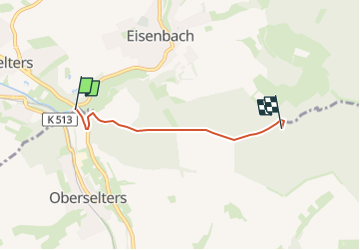
3.9 km | 4.8 km-effort
1h 5min
![](https://static1.geolcdn.com/siteimages/upload/files/16400158638029165_repeat_loop_refresh_sync_direction_icon.png)
No